Gobi Desert Statistics (2026): 40+ Facts on Size, Climate, Wildlife, and Dinosaur Discoveries
The Gobi Desert covers approximately 1,300,000 square kilometers — roughly the combined size of France, Germany, Spain, and the UK — making it the largest desert in Asia and the fifth or sixth largest on Earth (Encyclopaedia Britannica). Its temperature swings from −40°C in winter to +43°C in summer. Fewer than 40 individual Gobi bears survive in the wild.
These figures come from the IUCN Red List, the American Museum of Natural History, Encyclopaedia Britannica, and Mongolia’s protected-area authorities. Where population counts are contested or based on limited survey data, we say so explicitly. This page draws no figures from travel blogs or unattributed sources.
- Area: ~1,300,000 km² — largest desert in Asia, ~5th–6th largest on Earth (Encyclopaedia Britannica)
- Temperature range: −40°C to +43°C; daily swings up to 35°C; annual precipitation just 50–200 mm
- Gobi bear (mazaalai): ~31 individuals remaining — the world’s rarest bear (Gobi Bear Project / IUCN, 2023)
- Wild Bactrian camel: ~950 individuals in Mongolia and China combined; IUCN reclassified Endangered in 2025
- First scientifically confirmed dinosaur eggs found at the Flaming Cliffs (Bayanzag) in 1923 by Roy Chapman Andrews’ AMNH expedition
- Less than 5% of the Gobi’s surface is sand dunes; the rest is bare rock, gravel plains, and stony steppe
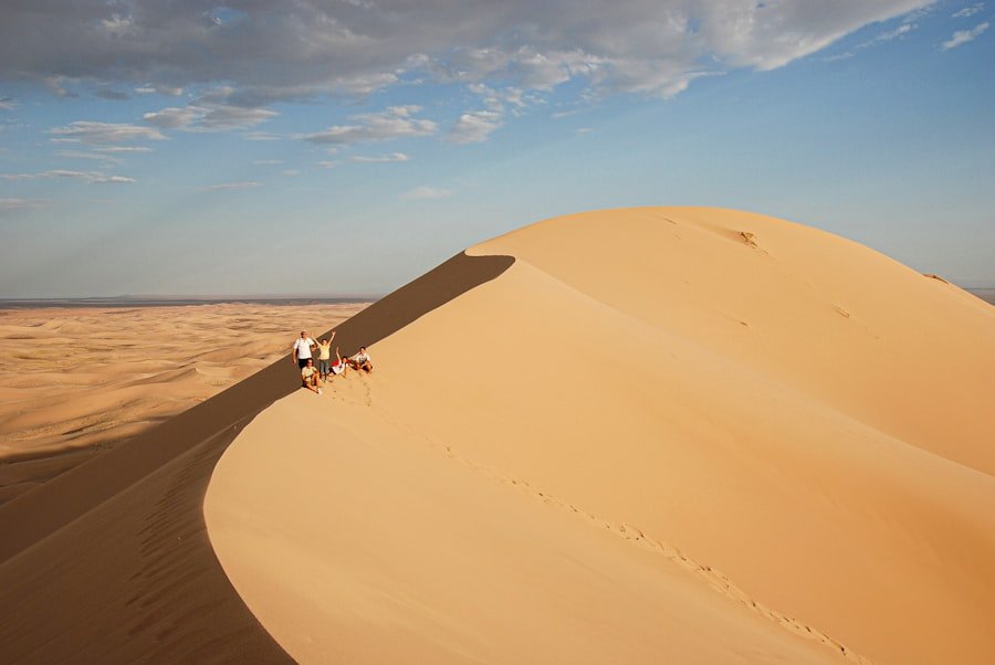
- Khongoryn Els dunes reach up to 300 m in height and extend ~100 km in length
- The Gobi is expanding at an estimated ~3,600 km² per year (estimate; Environmental Issues in Mongolia / Wikipedia citing scientific sources)
- Approximately 70% of Mongolia’s pastureland is degraded (UNDP / Mongolian government assessments)
Table of Contents
5. Desertification and Climate Change
7. The Gobi Desert by the Numbers
1. Size and Geography
The Gobi is not one ecosystem but a mosaic of gravel plains, rocky outcrops, steppe, and scattered sand fields stretching across southern Mongolia and northern China. At roughly 1,300,000 square kilometers, it spans a distance of ~1,600 km from southwest to northeast — longer than the distance from London to Istanbul (Encyclopaedia Britannica). The Mongolian portion alone covers more than 30% of the country’s total land area.
| Metric | Value | Source |
|---|---|---|
| Total area | ~1,300,000 km² | Encyclopaedia Britannica |
| Length (SW–NE) | ~1,600 km (1,000 miles) | Encyclopaedia Britannica |
| Width (N–S) | ~500–1,000 km (300–600 miles) | Encyclopaedia Britannica |
| Rank: largest desert in Asia | #1 | Encyclopaedia Britannica |
| Rank: largest desert on Earth | ~5th–6th (sources vary) | Encyclopaedia Britannica / scientific literature |
| Countries spanned | Mongolia + northern China | Encyclopaedia Britannica |
| Share of Mongolia’s land area | >30% | Mongolian geographic sources |
If you’re planning a trip through this landscape, our Gobi Wonders Expedition covers the desert’s most significant sites across seven days — the Flaming Cliffs, Khongoryn Els, Yolyn Am, and nomadic ger camps.
Primary source: Encyclopaedia Britannica — Gobi Desert
2. Extreme Climate
The Gobi is a cold desert — a distinction that surprises many visitors who picture shifting sand dunes and relentless heat. The same location can register −40°C in January and +43°C in July, a temperature range of over 80°C across the year (Encyclopaedia Britannica / scientific climate data). Daily swings of 35°C in a single 24-hour period are documented. This is a function of the desert’s mid-continental position, high elevation (900–1,500 m above sea level), and the rain shadow cast by the Himalayas and Tibetan Plateau to the south.
| Climate Metric | Value | Source |
|---|---|---|
| Record low temperature | ~−40°C | Encyclopaedia Britannica / climate records |
| Record high temperature | ~+40–43°C | Encyclopaedia Britannica / climate records |
| Typical daily temperature swing | Up to ~35°C | Scientific climate literature |
| Annual precipitation | 50–200 mm | Encyclopaedia Britannica |
| Average elevation | ~900–1,500 m above sea level | Geographic sources |
| Desert type | Cold (continental) desert | Scientific classification |
| Primary cause | Rain shadow of Himalayas / Tibetan Plateau | Scientific literature |
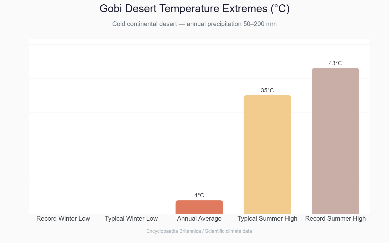
Annual precipitation below 100 mm is common in the western Gobi. The eastern Gobi receives more — up to 200 mm — but most of it falls as brief, intense summer rains that evaporate quickly from the rock-hard ground.
Primary source: Encyclopaedia Britannica — Gobi Desert
3. Rare Wildlife
The Gobi hosts some of the world’s most threatened large mammals. The Gobi bear (mazaalai) holds a population estimated at just ~31 individuals — fewer animals than the capacity of a standard school bus — making it the rarest bear subspecies on Earth (Gobi Bear Project, long-term genetic monitoring, 2023). These animals survive on minimal water sources in the Great Gobi Strictly Protected Area, Mongolia’s largest protected reserve.
| Species | Status | Population Estimate | Source |
|---|---|---|---|
| Gobi bear (mazaalai) Ursus arctos gobiensis | Critically Endangered (IUCN / Mongolian Red Book) | ~31 individuals (95% CI: 28–38) — latest available | Gobi Bear Project, long-term genetic monitoring (2023) |
| Wild Bactrian camel Camelus ferus | Endangered (IUCN, 2025 reassessment — previously Critically Endangered) | ~950 total: ~600 in China, ~350 in Mongolia — estimate | Wild Camel Protection Foundation; IUCN SSC 2025 |
| Snow leopard Panthera uncia | Vulnerable (IUCN) | Mongolia holds ~1,000 individuals (national estimate) — estimate | IUCN Red List; Snow Leopard Trust |
| Khulan (Asiatic wild ass) Equus hemionus | Near Threatened (IUCN) | Mongolia holds the world’s largest population (~49,000 — estimate) | IUCN Red List |
| Przewalski’s horse Equus ferus przewalskii | Endangered (IUCN) | Reintroduced to Mongolian steppe/Gobi fringe; ~2,000 globally — estimate | IUCN Red List; rewilding programs |
| Bactrian camel (domestic) | Not threatened | ~300,000 in Mongolia | Mongolian government livestock census |
Note: Population figures for Gobi-region wildlife are based on surveys conducted under challenging logistical conditions. Counts should be read as best available estimates, not precise censuses. IUCN assessments are updated periodically — check the IUCN Red List for the latest assessment date per species.
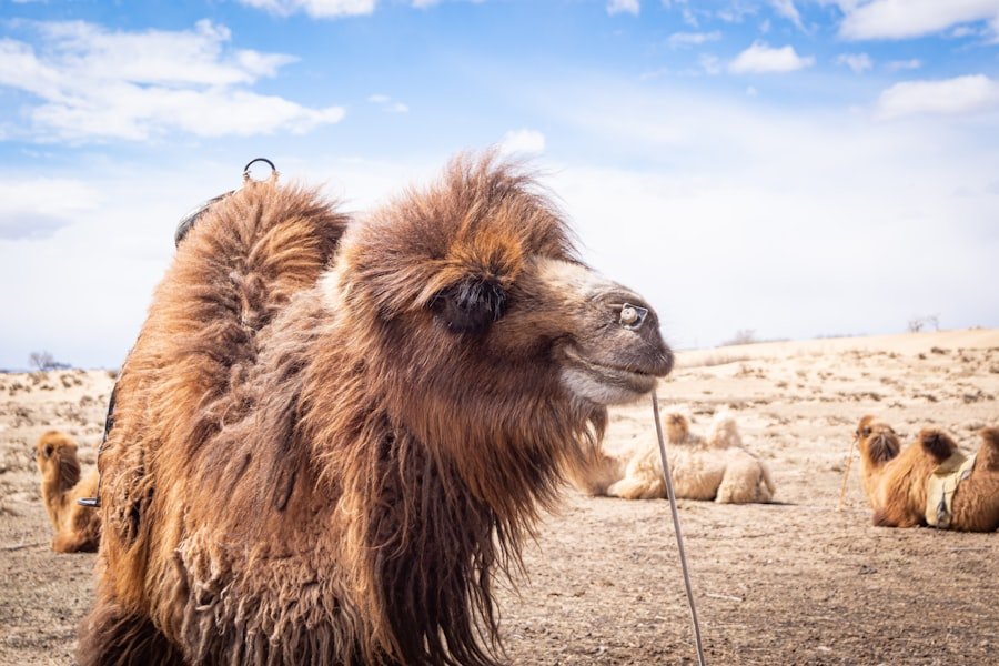
Our Mongolia tour itineraries that route through the Great Gobi Protected Area offer the best chance of spotting wild Bactrian camels from a respectful distance.
Primary source: IUCN Red List | Gobi Bear Project | Wild Camel Protection Foundation
4. Dinosaurs and Fossils
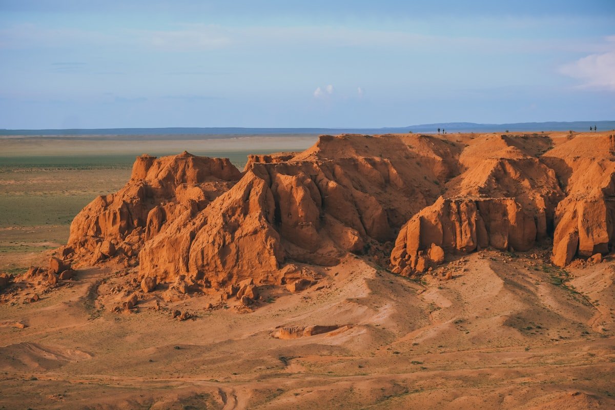
No desert has contributed more to the scientific understanding of dinosaurs than the Gobi. On July 13, 1923, a member of Roy Chapman Andrews’ American Museum of Natural History expedition found the first scientifically confirmed dinosaur eggs at the Flaming Cliffs (Bayanzag) — a discovery that transformed paleontology’s understanding of dinosaur reproduction (AMNH). The red-orange sandstone cliffs of Bayanzag, in Ömnögovi Province, continue to yield specimens nearly a century later.
| Discovery | Year / Details | Source |
|---|---|---|
| First scientifically confirmed dinosaur eggs | July 13, 1923; Flaming Cliffs (Bayanzag); Roy Chapman Andrews / AMNH Central Asiatic Expedition | American Museum of Natural History (AMNH) |
| Protoceratops skulls collected in 1923 season | More than 50 skulls; ~50 eggs including clutches | AMNH |
| Fighting Dinosaurs specimen | Found 1971 by Polish–Mongolian expedition; Velociraptor mongoliensis and Protoceratops andrewsi locked in combat; Djadokhta Formation | Wikipedia / AMNH; currently on display at AMNH |
| Age of Fighting Dinosaurs | 75–71 million years ago (Late Cretaceous) | Scientific literature |
| Nemegt Basin | One of the world’s richest Late Cretaceous fossil beds; yields large theropods including Tarbosaurus bataar and sauropods | Scientific literature |
| UNESCO Tentative List | Cretaceous Dinosaur Fossil Sites in the Mongolian Gobi inscribed on UNESCO World Heritage Tentative List | UNESCO World Heritage Centre |
The Flaming Cliffs are accessible as part of a standard Gobi itinerary. Our Gobi Desert travel guide covers practical logistics for reaching Bayanzag from Dalanzadgad.
Primary source: American Museum of Natural History — Dinosaur Eggs | UNESCO World Heritage Tentative List
5. Desertification and Climate Change
The Gobi’s boundaries are not fixed. The desert’s southern edge, where it meets China’s Inner Mongolia, is advancing at an estimated ~3,600 square kilometers per year — roughly the area of Luxembourg annually absorbed by desert conditions (estimate; multiple scientific sources). This figure is widely cited but based on regional assessments rather than a single definitive study; treat it as an order-of-magnitude estimate. The drivers are a combination of overgrazing, climate warming, and reduced vegetation cover.
| Metric | Value | Notes | Source |
|---|---|---|---|
| Gobi expansion rate (southern edge) | ~3,600 km² per year | Estimate — regional assessments, not single study | Scientific literature; Environmental Issues in Mongolia |
| Mongolia pastureland degraded | ~70% (some assessments: up to 90% show some degradation) | Estimate — varies by methodology | UNDP / Mongolian government assessments |
| Human vs. natural causation | ~87% of desertification attributed to human activity | Overgrazing, erosion, burning | Scientific literature (PMC review, 2021) |
| Vegetation growth rate change | Shrunk by factor of ~5 in severely affected zones | Estimate | Mongolian government / scientific sources |
| Northward creep into Mongolia | ~6–7 km per year (projected) | Projection, not confirmed measurement | Scientific projections |
Note: Desertification measurement is methodologically contested. Different studies use different definitions of “desertified land” and different baseline years. The figures above represent commonly cited ranges from peer-reviewed and governmental sources. No single authoritative global census exists.
Primary source: Sandstorms and desertification in Mongolia — PMC / NCBI (2021) | UNDP Mongolia
6. Iconic Landscapes
Most people picture the Gobi as an ocean of sand. The reality is different. Less than 5% of the Gobi’s surface is sand dunes — the overwhelming majority is bare bedrock, compacted gravel plains (called “gobi” in Mongolian, the word that gave the desert its name), and stony steppe (scientific surface composition studies). The sand dunes that do exist, however, are extraordinary.
| Landscape Feature | Key Statistic | Source |
|---|---|---|
| Sand dune coverage (% of Gobi area) | <5% | Scientific surface composition studies |
| Dominant surface type | Bare rock, compacted gravel (avg. 77% gravel by study area) | Scientific literature (ScienceDirect) |
| Khongoryn Els dunes — maximum height | Up to ~300 m | Wikipedia / Gobi Gurvansaikhan NP sources |
| Khongoryn Els dunes — length | ~100 km (some sources: up to 180 km) | Wikipedia |
| Khongoryn Els dunes — total area | >965 km² | Wikipedia / Gobi Gurvansaikhan NP |
| Khongoryn Els local name | Duut Mankhan (“Singing Dune”) | Mongolian geographic records |
| Yolyn Am gorge | Ice persists on the valley floor into mid-July (some years through August) due to narrow canyon microclimate | Geographic/traveler documentation |
| Yolyn Am name meaning | “Valley of the Vultures” (yol = Lammergeier/Bearded Vulture in Mongolian) | Mongolian etymology |
The “singing” at Khongoryn Els is caused by sand avalanches across the dune faces — a French scientific team attributed the resonance to a thin slate-like coating on the sand grains. On calm afternoons, the sound carries for kilometers.
Planning a visit to these sites? The Atlas Mongolia Travel team can help build an itinerary that pairs Khongoryn Els and Yolyn Am with the Flaming Cliffs in a single Gobi circuit.
Primary source: Wikipedia — Khongoryn Els | Wikipedia — Yolyn Am
The Gobi Desert by the Numbers
A single reference table of the highest-impact statistics from this page. Figures marked (estimate) are based on scientific assessments with methodological caveats noted in their respective sections above.
| Metric | Value | Source |
|---|---|---|
| Total area | ~1,300,000 km² | Encyclopaedia Britannica |
| Length SW–NE | ~1,600 km | Encyclopaedia Britannica |
| Width N–S | ~500–1,000 km | Encyclopaedia Britannica |
| Rank in Asia | Largest desert | Encyclopaedia Britannica |
| Global rank | ~5th–6th largest desert | Encyclopaedia Britannica (sources vary) |
| Countries covered | Mongolia + northern China | Encyclopaedia Britannica |
| Record low temperature | ~−40°C | Climate records |
| Record high temperature | ~+40–43°C | Climate records |
| Max daily temperature swing | Up to ~35°C | Scientific literature |
| Annual precipitation | 50–200 mm | Encyclopaedia Britannica |
| Elevation range | ~900–1,500 m asl | Geographic sources |
| Sand dune coverage | <5% of total Gobi area | Scientific surface studies |
| Gobi bear population | ~31 individuals (95% CI: 28–38) (estimate) | Gobi Bear Project, genetic monitoring (2023) |
| Wild Bactrian camel — global population | ~950 total (estimate) | Wild Camel Protection Foundation |
| Wild Bactrian camel — IUCN status | Endangered (reassessed 2025; previously Critically Endangered) | IUCN SSC, 2025 |
| First dinosaur eggs discovered | July 13, 1923 — Flaming Cliffs (Bayanzag) | AMNH |
| Expedition leader | Roy Chapman Andrews, American Museum of Natural History | AMNH |
| Fighting Dinosaurs specimen age | 75–71 million years (Late Cretaceous) | Scientific literature |
| Khongoryn Els dune height (max) | Up to ~300 m | Gobi Gurvansaikhan NP / Wikipedia |
| Khongoryn Els dune length | ~100 km | Wikipedia |
| Gobi expansion rate (estimate) | ~3,600 km² per year | Scientific literature |
| Mongolia pastureland degraded (estimate) | ~70% | UNDP / Mongolian government |
Frequently Asked Questions
How big is the Gobi Desert?
The Gobi Desert covers approximately 1,300,000 square kilometers, making it the largest desert in Asia and the fifth or sixth largest desert on Earth. It stretches roughly 1,600 km from southwest to northeast and up to 1,000 km from north to south, spanning southern Mongolia and northern China (Encyclopaedia Britannica).
What animals live in the Gobi Desert?
The Gobi’s most notable wildlife includes the Gobi bear (mazaalai), wild Bactrian camel, snow leopard, khulan (Asiatic wild ass), and the reintroduced Przewalski’s horse. The Gobi bear — with roughly 31 individuals remaining — is the world’s rarest bear subspecies. The wild Bactrian camel numbers around 950 globally and is listed as Endangered by the IUCN as of 2025.
Where were the first dinosaur eggs discovered?
The first scientifically confirmed dinosaur eggs were found on July 13, 1923, at the Flaming Cliffs — known in Mongolian as Bayanzag — in Mongolia’s Ömnögovi Province. The discovery was made by a team member of Roy Chapman Andrews’ Central Asiatic Expedition, operating on behalf of the American Museum of Natural History in New York.
Is the Gobi Desert mostly sand dunes?
No. Less than 5% of the Gobi’s surface is covered by sand dunes. The vast majority is bare bedrock, compacted gravel plains, and rocky steppe. The word “gobi” itself means gravel desert in Mongolian. The dunes that do exist — like Khongoryn Els — are spectacular precisely because they’re so unexpected amid the surrounding rock and gravel.
How cold does the Gobi Desert get?
The Gobi is a cold desert. Temperatures drop to around −40°C in winter and can spike to +43°C in summer, a range of over 80°C within a single year. Daily swings of up to 35°C are documented. The extreme cold is caused by the desert’s continental position, high elevation (900–1,500 m), and the blocking effect of the Himalayas on warm, moisture-bearing winds.
Is the Gobi Desert expanding?
Yes. Estimates suggest the Gobi’s southern boundary expands at roughly 3,600 square kilometers per year, primarily into China’s Inner Mongolia region. This figure is an estimate from regional scientific assessments, not a single authoritative census. The causes are approximately 87% human-driven — overgrazing, agricultural erosion, and deforestation — combined with climate warming (PMC/NCBI, 2021).
What is the Gobi bear?
The Gobi bear (mazaalai), Ursus arctos gobiensis, is a subspecies of the brown bear found only in Mongolia’s Great Gobi Strictly Protected Area. With a population estimated at around 31 individuals, it is the world’s rarest bear. It survives on scarce water sources in one of Earth’s harshest environments and is listed as Critically Endangered under the Mongolian Red Book and meets IUCN Critically Endangered criteria.
What is the Fighting Dinosaurs specimen?
The Fighting Dinosaurs is a fossil specimen discovered in 1971 during a Polish–Mongolian paleontological expedition in the Djadokhta Formation of the Mongolian Gobi. It preserves a Velociraptor mongoliensis and a Protoceratops andrewsi locked in combat 75–71 million years ago — direct physical evidence of predatory behavior. It is a declared national treasure of Mongolia and is currently on display at the American Museum of Natural History.
Methodology and Sources
This page separates well-established geographic data from contested or estimate-based figures:
Established (high confidence): Gobi area (~1.3M km²), geographic dimensions, temperature extremes, the 1923 dinosaur egg discovery, Fighting Dinosaurs specimen details, Khongoryn Els dimensions, desert type classification.
Estimates (lower confidence, methodology caveats apply): Gobi bear population count (based on genetic sampling of a very small population); wild Bactrian camel total (extrapolated from localized survey data); desertification rate (~3,600 km²/yr, derived from regional studies, not a single authoritative global census); Mongolia pastureland degradation (~70%, varies by study methodology).
Sources consulted:
- Encyclopaedia Britannica — Gobi Desert (geography, climate, dimensions)
- American Museum of Natural History — Dinosaur Eggs (Flaming Cliffs, 1923 discovery)
- American Museum of Natural History — Fighting Dinosaurs
- IUCN Red List (wild Bactrian camel, snow leopard, Przewalski’s horse, khulan)
- Gobi Bear Project (Gobi bear population, genetic monitoring)
- Wild Camel Protection Foundation (wild Bactrian camel population estimate)
- PMC/NCBI — Sandstorms and desertification in Mongolia (2021) (desertification causation data)
- UNESCO World Heritage Centre — Cretaceous Dinosaur Fossil Sites, Mongolian Gobi
- Wikipedia — Khongoryn Els (dune dimensions)
- UNDP Mongolia / Mongolian government assessments (desertification, pastureland degradation)
Last updated: June 2026. We review this page annually against the latest IUCN assessments and scientific literature.
Written by the Atlas Mongolia Travel team — a locally operated tour company based in Ulaanbaatar.
Featured photo by ulziibayar badamdorj on Unsplash | Wildlife photo by Bailley Schmidt on Unsplash | Dunes photo by Tengis Galamez on Unsplash
Atlas Mongolia Travel
Atlas Mongolia Travel is a locally operated tour agency based in Ulaanbaatar, Mongolia, specializing in authentic private and group tours across Mongolia.
Leave a Reply